NHRed.jpg)
A river is an obstacle before it is anything else. For two centuries the history of the Mill River in New Haven is mostly the history of getting across it — and then, once the railroad arrived, of what got built along it because the crossing was there.
A tidal stream
The Mill River rises in the uplands of Cheshire and runs about seventeen miles south through Hamden and New Haven into Long Island Sound. The lower river, the stretch you are standing on, is tidal: salt water pushes up it twice a day as far as the tide gate.
The ground here is clay, silt and sand — the floor of a shallow sea that sat between glacial periods. It is soft, it floods, and before it was filled it was marsh. None of that made it good to build on. All of it made it cheap.
EngineeringRecord.jpg)
Neck Bridge, 1641
English Puritans settled New Haven in 1638. Three years later they built the first bridge over the Mill River, called Neck Bridge, along what is now State Street. For most of two centuries that was the crossing — anyone going to Fair Haven went up to State Street and over.
In 1819 Eli Barnes helped pay for a bridge at Grand Avenue, privately, cutting the trip short. The city spent the next hundred years rebuilding both.
NewHavenMuseum1.jpg)
The railroad, 1839
The New Haven and Hartford Railroad opened in 1839, the city's first rail line, and carried its track over the Mill River on a bridge of red sandstone. That single decision did more to shape this riverbank than any other.
Before the railroad, industry on the Mill River meant water power: a gristmill, a carriage factory, a mill making wheels and axles, a paper mill, and from 1798 Eli Whitney's armory upstream. Those works had to sit where the current was. After the railroad, a factory only needed to sit where the freight was — and a site with a rail line on one side and a navigable tidal river on the other, minutes from a dense supply of labour, was as good as land got.
So the marshes were filled and the riverbank was taken. By the early 1900s the lower Mill River was lined with works making rubber boots, clocks, auto parts, cardboard, steam boilers, brass and wire.
The sandstone bridge was replaced in 1906-07 by the two concrete arches standing today. The Engineering and Building Record published the drawings in November 1908.
EngineeringRecord-b.jpg)
Three bridges, and one that stopped
Looking north from here you can see the sequence. The nearest bridge carried the New Haven, New London and Stonington Railroad, begun in 1852, east through Fair Haven and along the Connecticut shoreline; that line is abandoned now. The middle bridge is the 1906-07 arch, still carrying trains. The farthest is the Humphrey Street Bridge, built in 1952 to replace a 1909 crossing between State Street and Fair Haven.
The rails that went indoors
A main line is the part you notice. It is not the part that made this an industrial river.
What did that was the private siding — a spur thrown off the main line, across a yard, and in through the wall of a particular building, so that a boxcar could be loaded where the goods were made rather than carted to a station. Every serious works along this stretch had one or wanted one. It is why the factories sit where they sit: not near the river for the water, by the 1900s, but near the river because the rails were already there.
The clearest surviving example is a few hundred yards upstream, and it is worth the walk.
Paper, again
Before the railway, one of the works on this river was a paper mill, turning by water like everything else. A century later paper came back, and this time it came by rail.
The National Folding Box Company was assembled in New York in the early 1890s out of a group of smaller carton makers. In 1905 it chose New Haven as its production centre and bought an entire block at James Street — for the barge landing, for the spurs alongside, and for a workforce living within walking distance in Fair Haven, Cedar Hill and Barnesville. The four-storey plant went up in 1914.
By 1927 it was the largest and most prestigious folding box company in the world.
That is easy to underrate, because a box is not a glamorous object. But the whole twentieth-century idea of a branded product — something you recognise on a shelf, sealed, printed, identical every time — depends on somebody making the container. National printed for Budweiser, for Hershey's, for General Electric, for the cigarette companies. And for Peter Paul: it made the boxes for Mounds and Almond Joy, having helped start the company in the first place, as an outside investment.
A private siding ran off the main line, across the yard and in through the wall, so a boxcar could be filled where the boxes were made. The largest folding box plant in the world was fed by a track off the railway whose bridge you are looking at.
And then the jacket
Southern paperboard mills, sitting next to the timber, undercut New England on price. Federal Paper Board bought National in 1953 and kept the plant going until 1974, when it closed.
In 1976 a coach from Hamden Hall named David Beckerman moved his young sportswear company into the empty box factory and, that same year, took a licence from Major League Baseball. Before it, a replica team jacket was not really a product you could buy. Afterwards it was an industry. By the late 1980s the satin jacket with the S-and-star on the sleeve was one of the most recognisable objects in American popular culture — and it was designed and shipped from a building on the Mill River.
Starter went public in 1993, was winded by the 1994 baseball strike, and declared bankruptcy in 1999. The building still works: it houses ACES, the United Way of Greater New Haven and Workforce Alliance, and ACES bought it outright in May 2026.
A daylight factory built for folding cardboard in 1914 is now full of people helping other people find work. That is a better ending than most New England mill buildings get.
Look at the near bridge again with that in mind. It is not a bridge that took people anywhere. It is a bridge that took freight to a door.
A note on what is standing
The abandoned crossing has been coming apart for years, and the project records it as having recently come down into the river. If you are reading this on the trail and it looks different from what the sign shows, the sign is older than the river.
What it cost
This was before the Clean Water Act, and the river was treated as part of the plant. Owners put into it whatever they wanted to be rid of. The discharge ran downstream into the oyster beds that ringed the industrial area, and the oystermen and the factories fought over it for decades — an argument the factories won.
By 1970 the Mill River tested at four times the legal limit for swimming, and there was serious talk of paving it over.
The industry left instead. The river has been recovering since, and river herring still run up it each spring to spawn, the way they did before Neck Bridge.
The sign at this spot
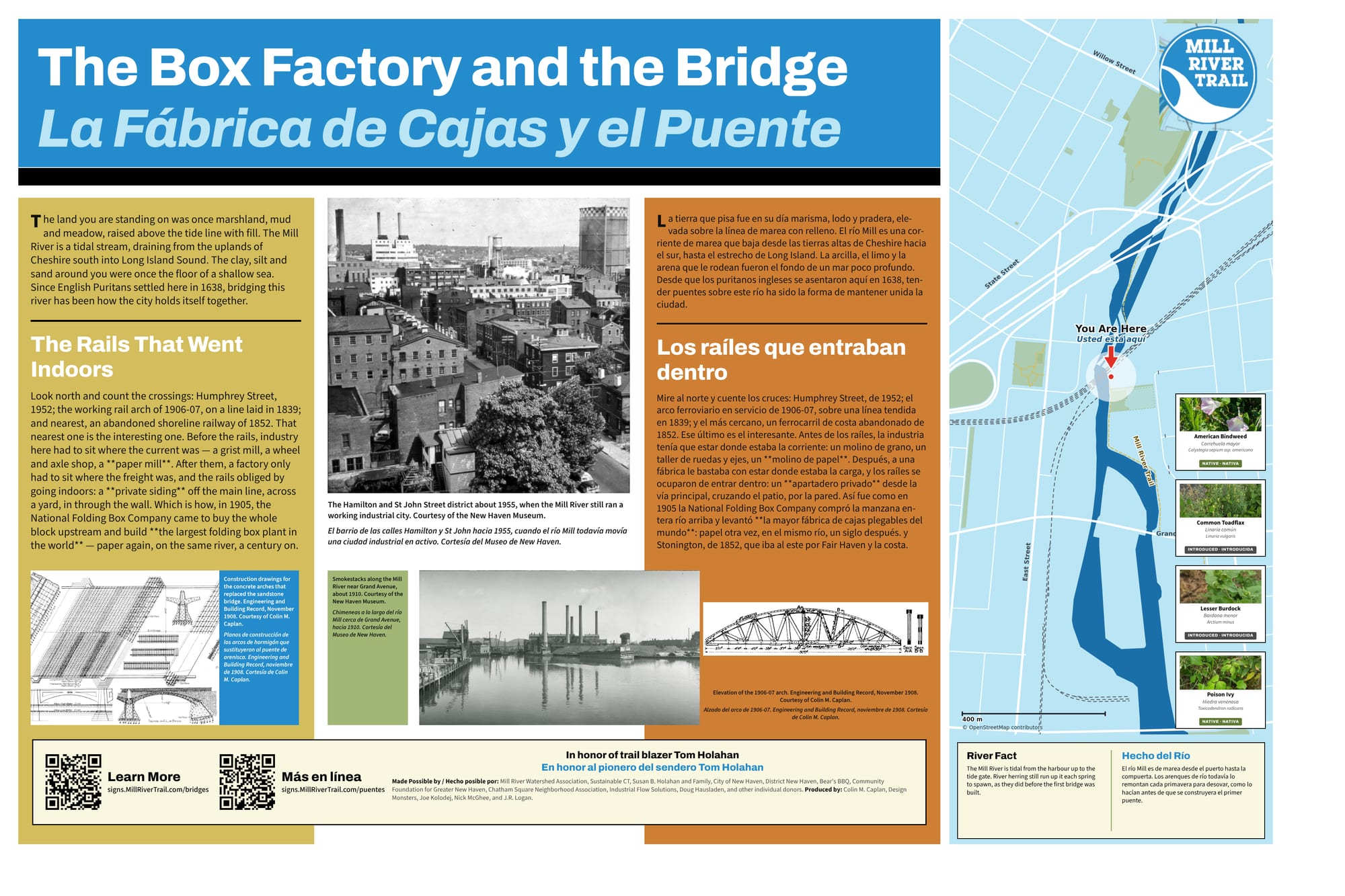
The full sign, in English and Spanish. Zoom in to read it.
Sources and further reading
Where a link goes to a scanned original — a newspaper page, a map, an engineering journal — it is the actual document, not a summary of it.
- 370 James St. — Home of the National Box Company and Starter, Inc. (New Haven Museum)
- ACES buys Fair Haven office building for $14.6M — New Haven Independent, May 2026
- Engineering and Building Record, Volume 58, November 1908
- The old Chapel Street Bridge — Library of Congress
- New Haven's industrial history — Yale-New Haven Teachers Institute
- Mill River history — Mill River Trail
- Mill River Watershed Based Plan — Save the Sound
Research and credits
Historical research for the Mill River Trail signage was carried out by Colin M. Caplan of Magrisso Forte and John R. Logan, with contributions from Jason Bischoff-Wurstle of the New Haven Museum and walk notes by Steve Hamm. Images are credited individually. Locator maps are drawn from OpenStreetMap, © OpenStreetMap contributors, ODbL.
This page last changed 2026-10-12.