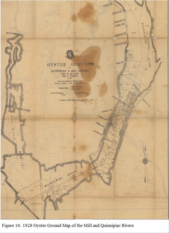
The first English names for this stretch of water were Dragon Point, Dragon River and Dragon Town. The usual explanation is the right one: harbour seals hauled out along these banks in numbers when the first European sailors came up the river, and "dragon" was near enough.
Seals are back in Long Island Sound in winter now. They were gone for a long time.
A separate place
Fair Haven sits about two miles from the New Haven Green, and it has spent much of its history being deliberately separate from it. The farmers here formed their own village in 1679 while still part of the New Haven Colony. A wooden bridge across the Quinnipiac in the late 1700s connected the two banks. The area between State Street and the Mill River became part of New Haven in 1784 and was called New Township. Fair Haven separated again in 1837, with a population of about a thousand.
A sea captain who visited in 1747 was struck enough by the place to call it Fayre Haven, and the name replaced the dragons.
Clamtown
What Fair Haven had was oysters, and nearly everyone in it worked them in one way or another: building boats, making kegs, cultivating and harvesting the beds, buying and selling the catch. By the middle of the 19th century New Haven's oyster trade was second only to Baltimore's by volume, and the nickname for the village was Clamtown.
The boat they developed for the work was the sharpie: long, narrow, flat-bottomed, shallow enough to work the beds and fast enough to get the catch home. It is one of the few American small-craft designs to come out of a specific fishery in a specific place, and it came out of this one.
Bigger vessels worked from here too, trading to the West Indies and bringing back sugar, molasses and fruit. The First Church on Grand Avenue had forty-eight ship captains in its congregation, and its 237-foot spire was the landmark returning sailors looked for, until a storm took a hundred feet off it in 1877.
The race at midnight
The public beds were closed all summer and the law came "off" at midnight on the first of November. What happened then was a spectator sport.
Ernest Ingersoll wrote it down for the 1880 census, and it is worth having in his words:
On the day preceding, farmers flocked into Fair Haven from all the surrounding country, and brought with them boats and canoes of antique pattern and ruinous aspect. These rustics always met with a riotous welcome from the town-boys, who hated rural competition. They were very likely to find their boats, if not carefully watched, stolen and hidden before they had a chance to launch them, or even temporarily disabled… As midnight approached, men dressed in oilskin, and carrying oars, paddles, rakes, and tongs, collected all along the shore, where a crowd of women and children assembled to see the fun… There were sharpies, square-enders, skiffs, and canoes, and they lined the whole margin of the river and harbor on each side in thick array… No eye could see the great face of the church-clock on the hill, but lanterns glimmered upon a hundred watch-dials, and then were set down, as only a coveted minute remained. There was a hush in the merriment along the shore, an instant's calm, and then the great bell struck a deep-toned peal. It was like an electric shock. Backs bent to oars, and paddles churned the water. From opposite banks navies of boats leaped out and advanced toward one another through the darkness, as though bent upon mutual annihilation.
Ingersoll places this on the Quinnipiac at Fair Haven. He does not mention the Mill.
The watch houses
An oyster bed cannot be fenced. Once the beds stopped being a common and became private leaseholds, somebody had to sit out on the water all night and watch them, and the harbour grew a scatter of small wooden watch houses to sit in.
They were ordinary enough to turn up in the newspaper as addresses — a want-ad in 1881 tells applicants to "apply at the WATCH HOUSE, Long Wharf." One watchman on the east side of the harbour was reported in 1885 to have taken sixty-five pounds of eels in a day, which tells you something about how the nights passed.
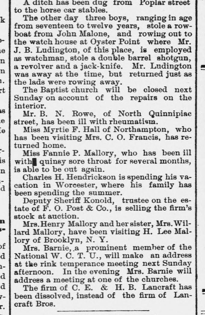
And they were armed. In September 1886 three boys, aged twelve to seventeen, stole a rowboat and pulled out to the watch house at Oyster Point, where J. B. Ludington was employed as watchman. They took a double barrelled shotgun, a revolver and a jack-knife. Ludington was away, and got back just as they were rowing off.
You will read that New Haven's watch houses stood on stilts out in open water. That picture belongs to the Chesapeake, where cabins on driven pilings stood miles offshore. Here the ice and the sound's wave action would have taken them; our watch houses sat on wharf heads, on the low barrier spits, and on pilings close in. Close enough that you had to row.
The collapse
The oyster industry fell apart in the early 20th century. Overfishing did part of it; pollution did the rest. The beds sat downstream of an industrial river that had been treated as a drain for decades, and the oystermen fought the factories over the water for years without winning.
There was also a single bad autumn that changed everything. In October 1894 typhoid fever broke out at Wesleyan University in Middletown, and it struck only the fraternities that had served raw oysters at their initiation banquets. Herbert W. Conn, a Wesleyan biologist, worked back along the supply chain to a Fair Haven dealer. The oysters had been dredged from clean deep water — but, as the trade routinely did, they had been moved to floats in the brackish river to fatten before packing, and the floats were sitting downstream of a sewer outlet from a house where somebody was recovering from typhoid.
It was the first clear demonstration in the United States that oysters could carry typhoid, and it is a piece of world epidemiology that happened to this river. The state began condemning beds near New Haven.
Thirty years later a much larger typhoid epidemic ran through New York, Chicago and Washington — about 1,500 sickened, roughly 150 dead. Those oysters were traced to West Sayville on Long Island, not here. It did not matter. Demand collapsed by more than half, every grower on the Sound was suspect, and the National Shellfish Sanitation Program that followed in 1925 closed urban estuaries like this one to direct market harvesting for good.
A word about a story you may hear: that the government burned New Haven's oyster houses down. There is no record of it, and the epidemic that is usually attached to the story belongs to Long Island. What City Point oystermen remembered burning were barrels — condemned shipments pulled off freight trains at the rail yards and destroyed on the spot so they could not be resold. Burning barrels and closed businesses, told and retold for three generations, are the likeliest origin of the burning buildings.
An adult oyster filters up to fifty gallons of water a day. The beds were not only a business, they were the harbour's filtration system, and losing them made the water worse in a way that made it harder to bring them back.
Now
Oystering on the Quinnipiac has been rebuilding, on cleaner water. The seals are back each winter. Watch also for the Asian shore crab, a small aggressive newcomer that arrived in ships' ballast and is now the most common crab on many Long Island Sound shorelines.
The sign at this spot
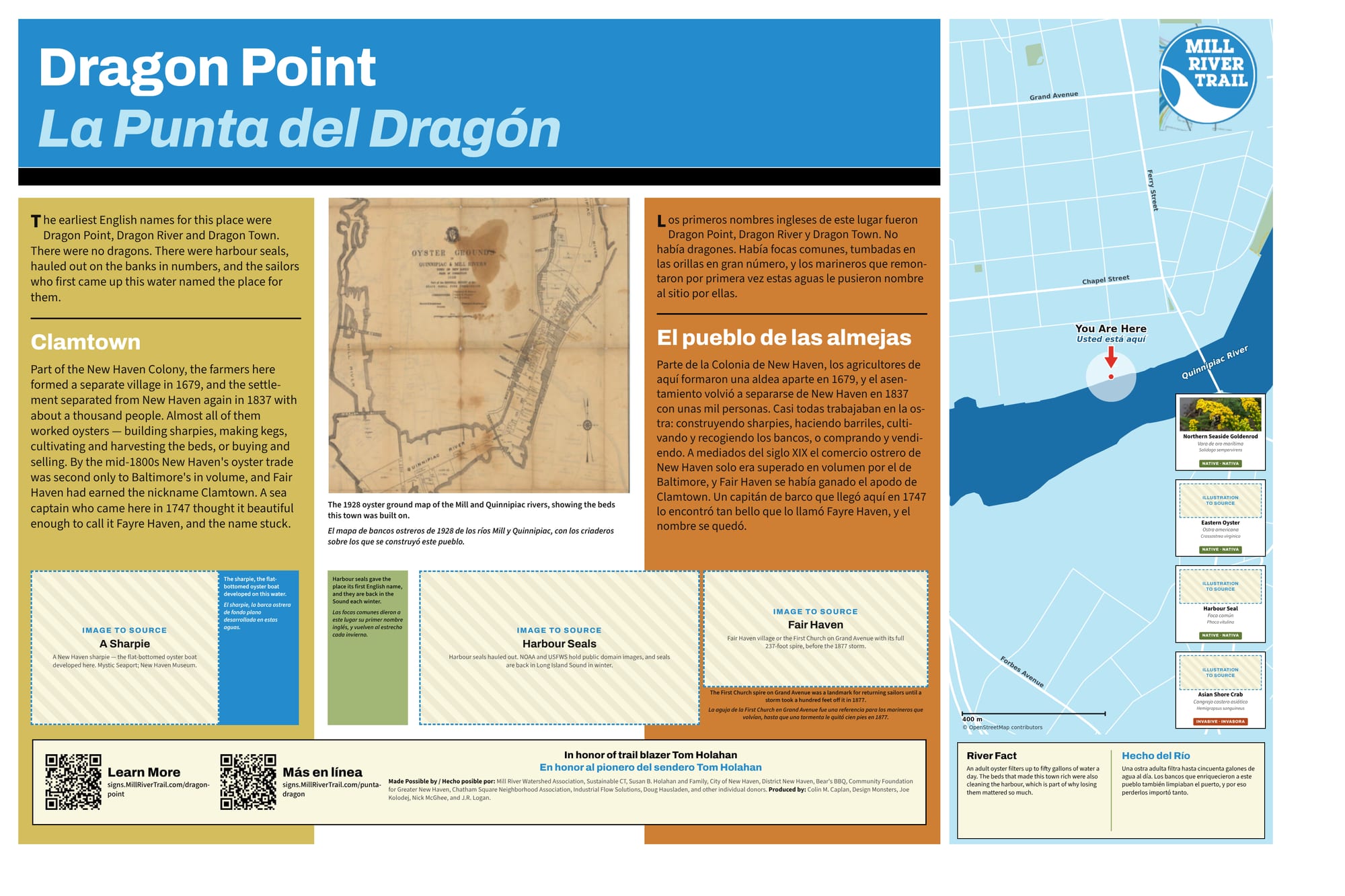
The full sign, in English and Spanish. Zoom in to read it.
This sign is still a draft. The hatched boxes are photographs that have not been sourced yet.
Sources and further reading
Where a link goes to a scanned original — a newspaper page, a map, an engineering journal — it is the actual document, not a summary of it.
- Ernest Ingersoll, The Oyster-Industry (Tenth Census, 1881) — the midnight race, p. 63-64
- The Oyster Point watch house robbery — Morning Journal and Courier, 9 September 1886
- Herbert William Conn, who traced the 1894 Wesleyan typhoid outbreak to oysters
- Oyster-borne typhoid fever, winter of 1924-25 — Food Safety News
- Oystering in Connecticut, from colonial times to today — Connecticut History
- Fair Haven, oystering and Clamtown — Yale-New Haven Teachers Institute
- Dragon Point — Connecticut Historical Collections
- What happened to the oysters — Yale-New Haven Teachers Institute
- Mill River Watershed Based Plan — Save the Sound
Research and credits
Historical research for the Mill River Trail signage was carried out by Colin M. Caplan of Magrisso Forte and John R. Logan, with contributions from Jason Bischoff-Wurstle of the New Haven Museum and walk notes by Steve Hamm. Images are credited individually. Locator maps are drawn from OpenStreetMap, © OpenStreetMap contributors, ODbL.
This page last changed 2026-10-12.