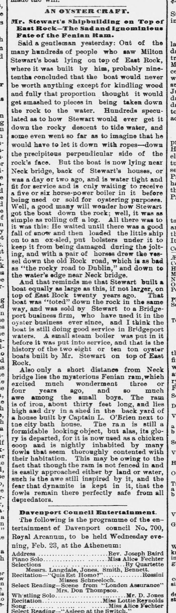
East Rock is the most obvious thing in New Haven and the easiest to take for granted. It is a 365-foot cliff of basalt — trap rock — formed when a sheet of lava cooled underground roughly 200 million years ago, as the continent was pulling away from Africa. Glaciers later stripped the softer material off its face.
What is less obvious is that it was very nearly not a park.
Private ground
Through the middle of the 1800s the land that is now East Rock Park was divided among several private owners, and they used it the way you would expect people to use a large exposed mass of good building stone: they quarried it. A guide to the park printed in 1884 still routes visitors past "the old Stewart road" near the quarry sites.
The man who built boats on top of a cliff
The top of the rock belonged to Milton J. Stewart. He had followed the sea once, and he lived up there in the stone house he had built, with dogs, cats, cows and a bad-tempered black horse, three hundred feet above New Haven.
And he built boats. Not model boats — eight-to-ten-ton oyster craft, the kind that went out on the Sound under a small steam boiler. He built them on the summit, in full view of a city that assumed he had lost his mind.
Out of the many hundreds of people who saw Milton Stewart's boat lying on top of East Rock, where it was built by him, probably nine-tenths concluded that the boat would never be worth anything except for kindling wood.
They were wrong twice over. His method was to wait for a heavy snow, load the hull onto an ox-sled with bolsters under it to take the jolting, and walk a pair of horses down the old Rock road — "which is as bad as the rocky road to Dublin" — to tide water near Neck Bridge. He did it at least twice, roughly twenty years apart. One of the two boats was sold to a Bridgeport firm and was still working the oyster beds there when the Journal and Courier wrote the story up in February 1887.
Not everything he started came down. He also began a 35-foot schooner and told the neighbours that eighteen or twenty yoke of oxen would fetch it to the water. That one had to be pulled apart on the summit and burned as firewood.
He did not go quietly, either. The city wanted the rock; Stewart said he owned it and meant to die on top of it, and it took condemnation proceedings to move him.
There is one more story, and it should be labelled as a story: a Brooklyn paper claimed in 1899 that Stewart had once walked into New Haven prophesying that Long Island Sound would rise and drown Connecticut, that hundreds believed him, and that the boat on the summit was his ark. It is a good tale, told twelve years after the fact by a newspaper a long way away, and nobody has yet found it in a New Haven paper. Treat it as folklore until somebody does.
Making a park
The city started buying parcels, and in 1880 created a parks commission to manage what it had assembled. Ultimately the park reached about 427 acres across New Haven and Hamden.
Its principal designer was Donald Grant Mitchell, a New Haven writer and landscape designer who also laid out Edgewood Park. The Olmsted Brothers firm — the successor practice to Frederick Law Olmsted — designed the portion of the park along the Mill River, including Rice Field.
In 1887 the Soldiers and Sailors Monument was built on the summit, and the rock acquired the silhouette it has now.
And nearly lost again
In the 1960s the state proposed running a highway connector along the Mill River and through the park. Residents organised against it and stopped it — a 1965 state law let the city's aldermen refuse the taking — though Interstate 91 still took about ten acres.
A park is not a natural feature. It is a decision that has to keep being made.
What is here now
Peregrine falcons hunt and roost along this face — the updraughts off the trap rock make it good raptor country, and the city below supplies the pigeons. They do not nest here, and it is worth knowing where they do. In 1999 Steve Broker found a pair holding territory on the cliffs of West Rock, across the city; the following spring they produced the first peregrine egg laid on a Connecticut cliff in sixty years, after DDT had wiped the species out as a breeding bird east of the Rockies. Their descendants are still there. If you see a falcon over East Rock, it very likely nests on the other rock.
In the woods, watch for garlic mustard and Japanese barberry — both introduced, both aggressive, and both changing what can grow underneath. The barberry does something less obvious too: it holds humidity at ankle height, and the ticks like that.
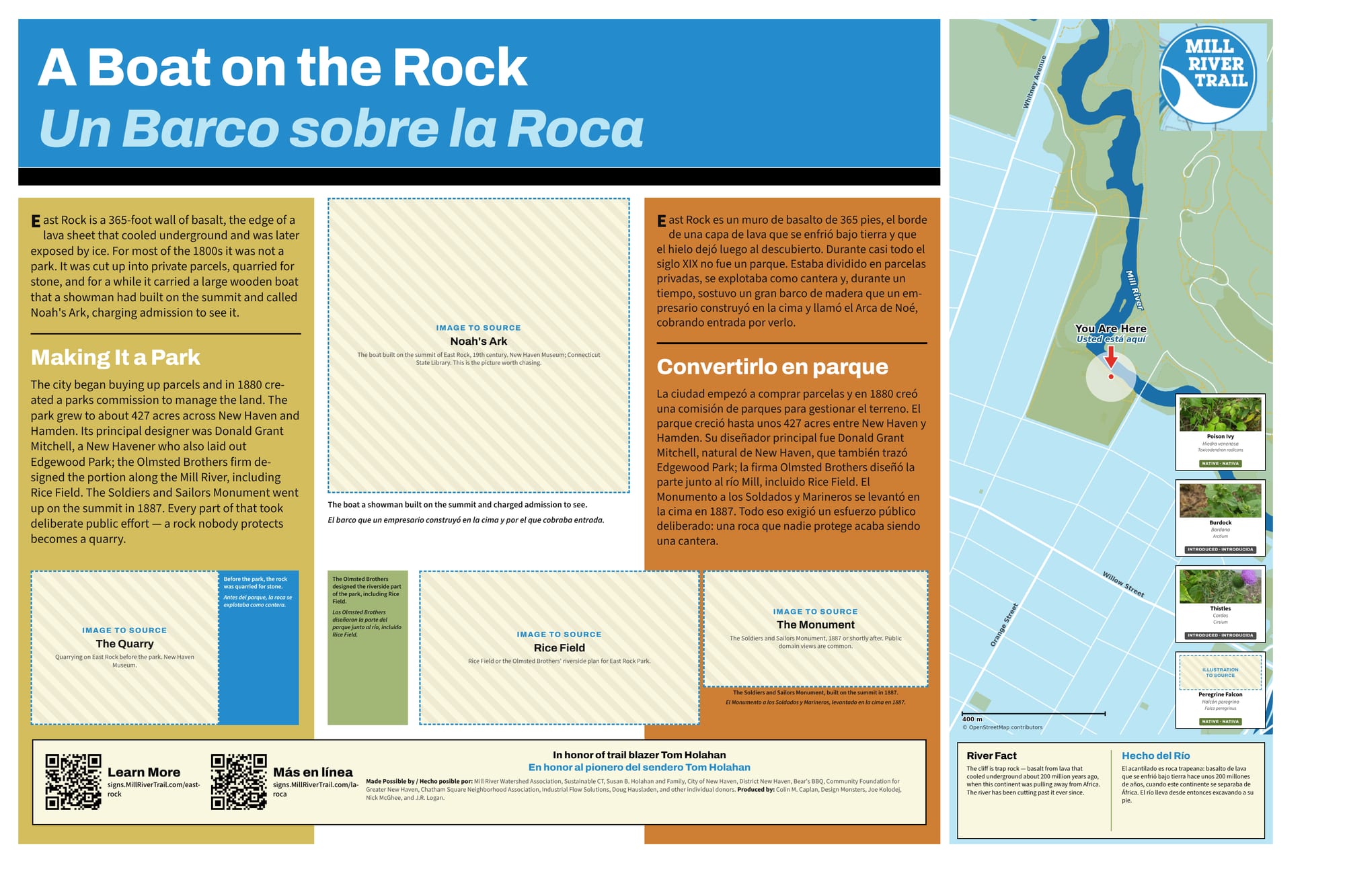
The sign at this spot
The full sign, in English and Spanish. Zoom in to read it.
This sign is still a draft. The hatched boxes are photographs that have not been sourced yet.
Sources and further reading
Where a link goes to a scanned original — a newspaper page, a map, an engineering journal — it is the actual document, not a summary of it.
- "An Oyster Craft" — Morning Journal and Courier, 22 February 1887
- "East Rock Park" guide extract — Morning Journal and Courier, 8 July 1884
- New Haven's Sentinels: the story of East Rock and West Rock
- The East Rock Connector — Connecticut roads
- Report of the New Haven Civic Improvement Committee, 1910
- Mill River history — Mill River Trail
Research and credits
Historical research for the Mill River Trail signage was carried out by Colin M. Caplan of Magrisso Forte and John R. Logan, with contributions from Jason Bischoff-Wurstle of the New Haven Museum and walk notes by Steve Hamm. Images are credited individually. Locator maps are drawn from OpenStreetMap, © OpenStreetMap contributors, ODbL.
This page last changed 2026-10-12.