Stand at the gate and you are standing on a boundary. Downstream the Mill River is an arm of the sea: salt water on the flood tide, mud flats on the ebb, twice a day, every day. Upstream it is a fresh water stream. The change is abrupt because it is engineered.
Why the gate is here
A tidal river floods. Push a high tide up against heavy rain coming down and the water has nowhere to go but sideways, over whatever has been built on the old marsh — which, on the Mill River, is most of it.
New Haven had been told this. The 1910 city plan by Cass Gilbert and Frederick Law Olmsted recommended a tide gate, along with a protective buffer of open land along the river rather than the vertical walls the city would eventually build.
Flooding was not the only argument. Salt marsh breeds salt-marsh mosquitoes, and in the 1910s New Haven ran a serious campaign against them — ditching the meadows, spreading oil on standing water, and, as a newspaper account of the 1912 season put it, "looking after the tide gates." The city put gates across the West River in 1919 for exactly that reason. Gates went across the Mill River in the same era, at what is now the Interstate 91 crossing.
Who designed it, and when
For years this project could not say when the gates were built. It can now say when they were drawn, because the correspondence survives.
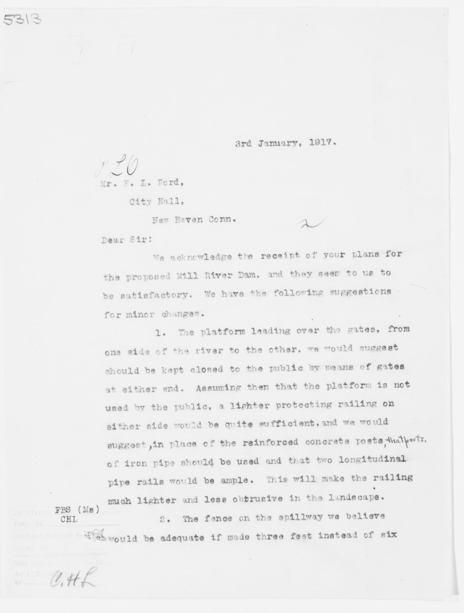
The designer was Frederick L. Ford, New Haven's city engineer, working from Room 18 of City Hall. He sent his plans to the Olmsted Brothers, the landscape firm advising the city on East Rock Park, and on 3 January 1917 they wrote back:
We acknowledge the receipt of your plans for the proposed Mill River Dam, and they seem to us to be satisfactory. We have the following suggestions for minor changes. 1. The platform leading over the gates, from one side of the river to the other, we would suggest should be kept closed to the public… a lighter protecting railing on either side would be quite sufficient… This will make the railing much lighter and less obtrusive in the landscape. 2. The fence on the spillway we believe would be adequate if made three feet instead of six feet high. A similar fence… should also be built on top of the river walls.
That is the structure you are looking at, being argued over at the level of railing heights, in January 1917. A blueprint of the Mill River section had gone to the Olmsted office as early as November 1915.
The letter is on this sign. It sits in the Olmsted Associates Records at the Library of Congress, job file 5313 — East Rock Park, New Haven — along with three hundred and fifty other pages nobody on this project had read.
What we still cannot say is when the concrete was poured. One recent research summary gives 1935, built with New Deal relief labour under the state's mosquito programme, and the 1930s were certainly when federal crews ditched and diked salt marshes the length of this shore. But the design was finished eighteen years earlier, and the city put gates across the West River in 1919. Whether the Mill River gates went in with them, or waited for the Depression, or were built twice, is the question. If you know where the contract is, the trail would like to hear from you.
It does the job it was built for. It also changed the river permanently.
Where the sea legally ends
One thing about the gates is fixed beyond argument, because it is written into Connecticut regulation. The state divides its waters into a marine district and an inland district, and it draws the line stream by stream. For this river the rule reads:
Mill River, New Haven — marine district: up to and including below tide gates at State Street Bridge. Inland district: all waters above.
Which fish you may take, in what season, under which licence, changes at this structure. A hundred years ago somebody built a barrier to keep salt water off the marsh; the state has since accepted it as the place where the sea ends. An engineering decision became a boundary on a map.
The spring run
River herring — alewives and blueback herring — are anadromous: they live at sea and spawn in fresh water, returning each spring to the river where they hatched. Historically they ran the Mill River in enormous numbers, and they fed everything, from osprey and eagles to striped bass waiting at the mouth to the people who netted them off the banks.
A run needs a clear path. The Whitney dam closed the upper river in 1860. Structures downstream narrow what is left. Fish that can find no way past a barrier simply do not spawn that year.
Undoing some of it
Connecticut has spent the last few decades reopening rivers: fish ladders and bypass channels built around dams, tide gates replaced with self-regulating designs that let fish through while still holding back storm surge, and in a growing number of cases dams removed altogether. Each project adds back miles of spawning habitat, and the herring find it quickly.
What to look for
In April and May, look for movement in the shallows and for the birds that follow it — osprey overhead, cormorants and herons working the edges. The tall feathery reed along the banks is Phragmites, an aggressive invader that crowds out the native marsh grasses fish and crabs shelter in, and it spreads fastest on disturbed ground.
The sign at this spot
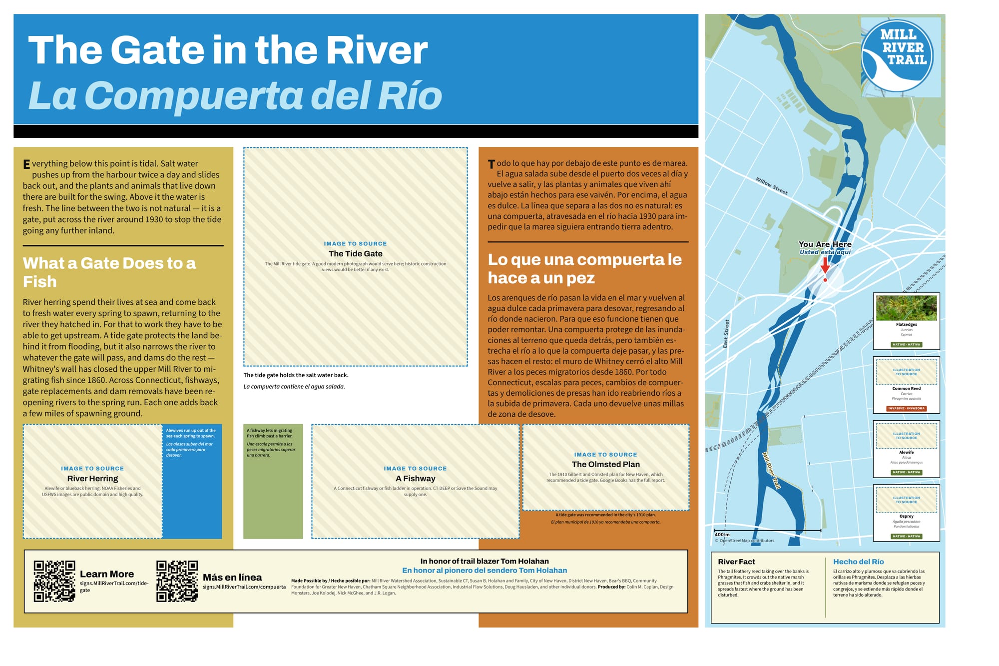
The full sign, in English and Spanish. Zoom in to read it.
This sign is still a draft. The hatched boxes are photographs that have not been sourced yet.
Sources and further reading
Where a link goes to a scanned original — a newspaper page, a map, an engineering journal — it is the actual document, not a summary of it.
- Report of the New Haven Civic Improvement Committee, 1910 — Gilbert and Olmsted
- Olmsted Associates Records, job file 5313 — East Rock Park, New Haven, 1917-1931 (Library of Congress)
- Olmsted Associates Records, job file 5313 — East Rock Park, New Haven, 1914-1916
- Conn. Agencies Regs. § 26-108-1 — inland waters and marine district defined
- Mosquito work of the 1912 season — The New Haven Union, 30 June 1912
- New Haven's Mill River: a brief history — Yale Water Management
- River herring — NOAA Fisheries
- Mill River Watershed Based Plan — Save the Sound
- Mill River history — Mill River Trail
Research and credits
Historical research for the Mill River Trail signage was carried out by Colin M. Caplan of Magrisso Forte and John R. Logan, with contributions from Jason Bischoff-Wurstle of the New Haven Museum and walk notes by Steve Hamm. Images are credited individually. Locator maps are drawn from OpenStreetMap, © OpenStreetMap contributors, ODbL.
This page last changed 2026-10-12.